

AI takes flight to revolutionise forest monitoring

Cambridge researchers are harnessing artificial intelligence to improve how forests are monitored. Associate Professor Dr Emily Lines and Research Associate Dr Harry Owen are using billions of laser-captured data points to measure biodiversity and make carbon accounting more accurate.
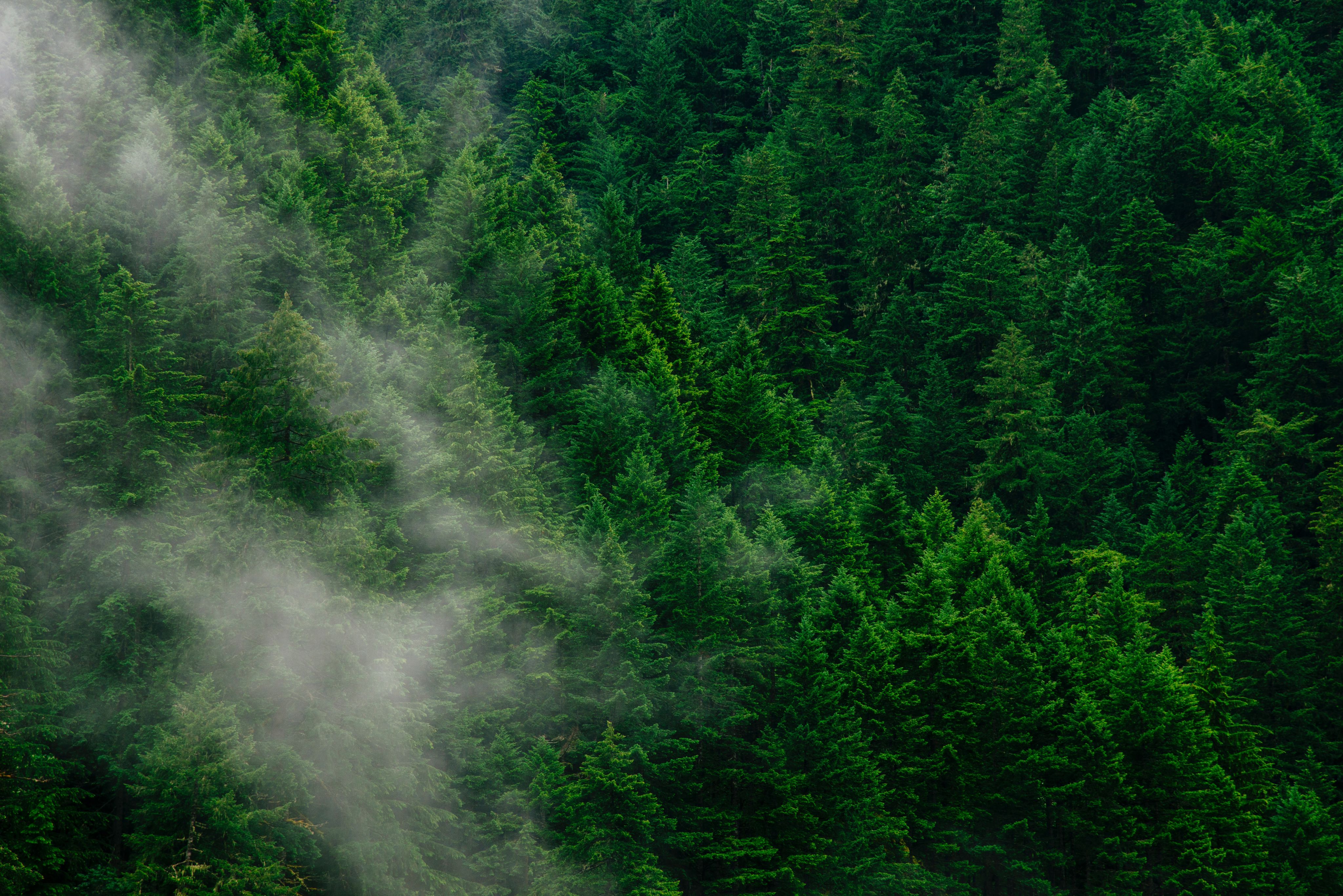
Forests play a crucial role in our global ecosystem, absorbing and storing carbon dioxide, regulating rainfall and moderating the climate. The United Nations says that forests cover 31 percent of the world and are home to more than 80 percent of all land animals, plants and insects. Large-scale forest monitoring can help us to understand how climate change is impacting these important ecosystems.
Forests are often described as the ‘lungs of the Earth’, absorbing twice as much carbon as they emit, acting as carbon sinks (storing CO2 in their branches, roots and leaves). Carbon sinks are essential to climate mitigation and limiting further global temperature rises.
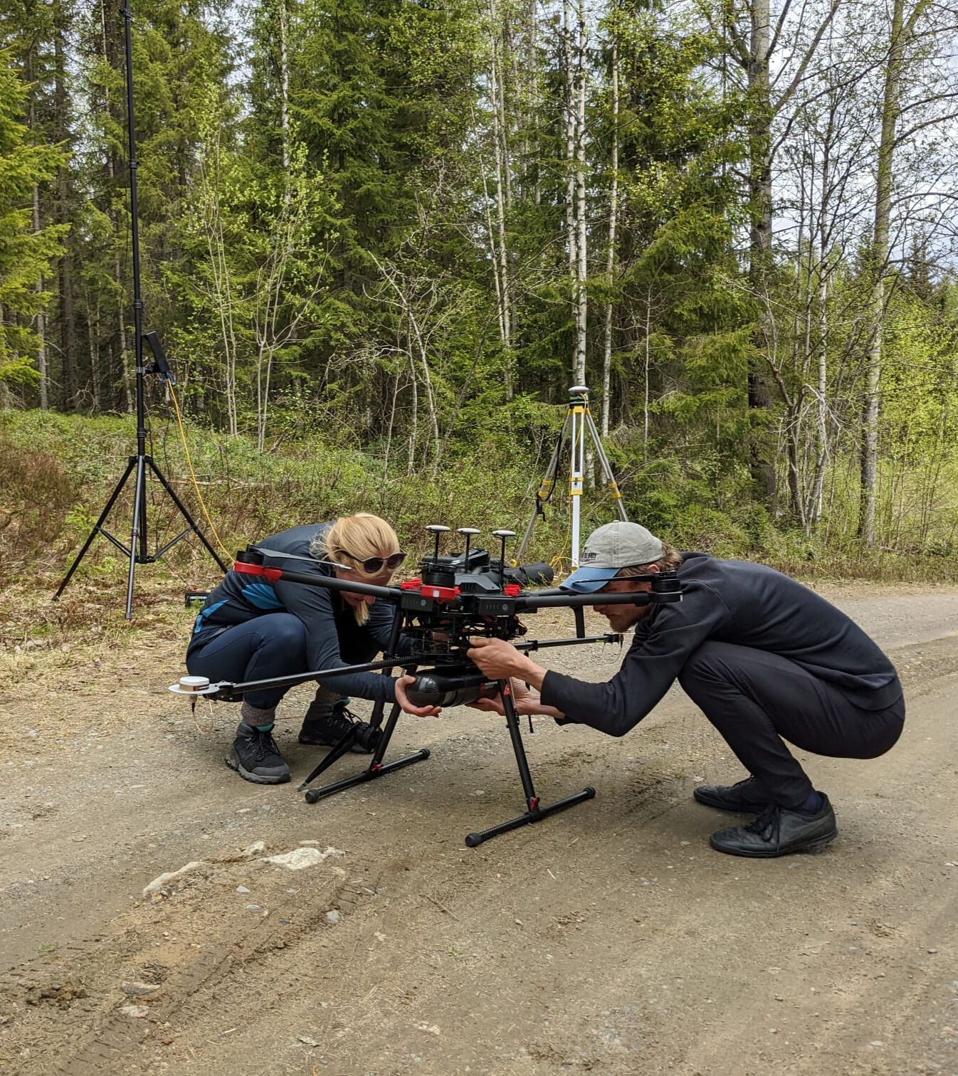
Dr Emily Lines, Co-Director of the Cambridge Centre for Earth Observation, and her team have been monitoring forests across Europe to collect data from ground-based instruments such as Terrestrial Laser Scanning, drones and even traditional tape measures.
From this, the team hopes to directly monitor Essential Biodiversity Variables (EBVs) with the help of AI. EBVs are a set of core variables that will collectively show the effect of anthropogenic change on biodiversity.
The Natural History Museum likens EBVs to a share price in a biodiversity stock market that measures the value of many different aspects of biological diversity. The Essential Biodiversity Variables are what varies over time.
An initial list of EBVs has been refined through extensive consultation and discussion with biodiversity scientists, and are grouped into six classes:
The ability to measure these EBVs will improve carbon accounting and biodiversity credits.
Processing this substantial amount of raw data into meaningful metrics is a significant challenge.
It requires a lot of human effort and limits the number of trees a single researcher can process. Dr Harry Owen recalls in the early days of his PhD spending a vast amount of time extracting key measurements such as crown size to understand the forests from big datasets.
“In a 30x30 metre area, you were dealing with millions and millions of data points”, Owen said.
Lines and Owen are now using AI and drones to speed up this process to just a few minutes from hours and days. Owen has been building an AI model, using ‘deep learning’, to automatically classify data points into individual trees and break them down into 3D components such as wood and leaves. This will reveal how carbon is stored in each tree and where microhabitats are formed.
“It’s pretty straightforward to fly a lot of these smaller drones, they have a huge potential for being an important part of the conservation toolkit and monitoring toolkit – and AI is taking the manual labour bottleneck and accelerating it,” Lines said.
This is one of the several ground-breaking projects under a new Cambridge focus on AI for Climate and Nature, which has received seed funding from ai@cam, the University’s flagship AI mission.


Credit: Emily Lines - Eastern Finland
Credit: Emily Lines - Eastern Finland

Dr Emily Lines and Dr Harry Owen in Eastern Finland
Dr Emily Lines and Dr Harry Owen in Eastern Finland
Data collected by Lines and her team from across Europe, along with other public forest data, is being used to train the AI model. Owen has undergone the lengthy process of manually labelling more than 50 million data points in a single plot - separating them into individual trees ‘leaf’ and ‘wood’ elements. This manual labelling is used to train the AI model to create a 3D map based on laser-scanned data.
“We want to go from raw laser scanning data to measurements like crown volume, canopy cover and structure, and microhabitat information, which will tell us about essential biodiversity variables,” Owen explained.
The pair hope that their 3D-model algorithm will speed up the forest monitoring pipeline, going from raw data to 3D models to key ecological measures without needing much expertise.

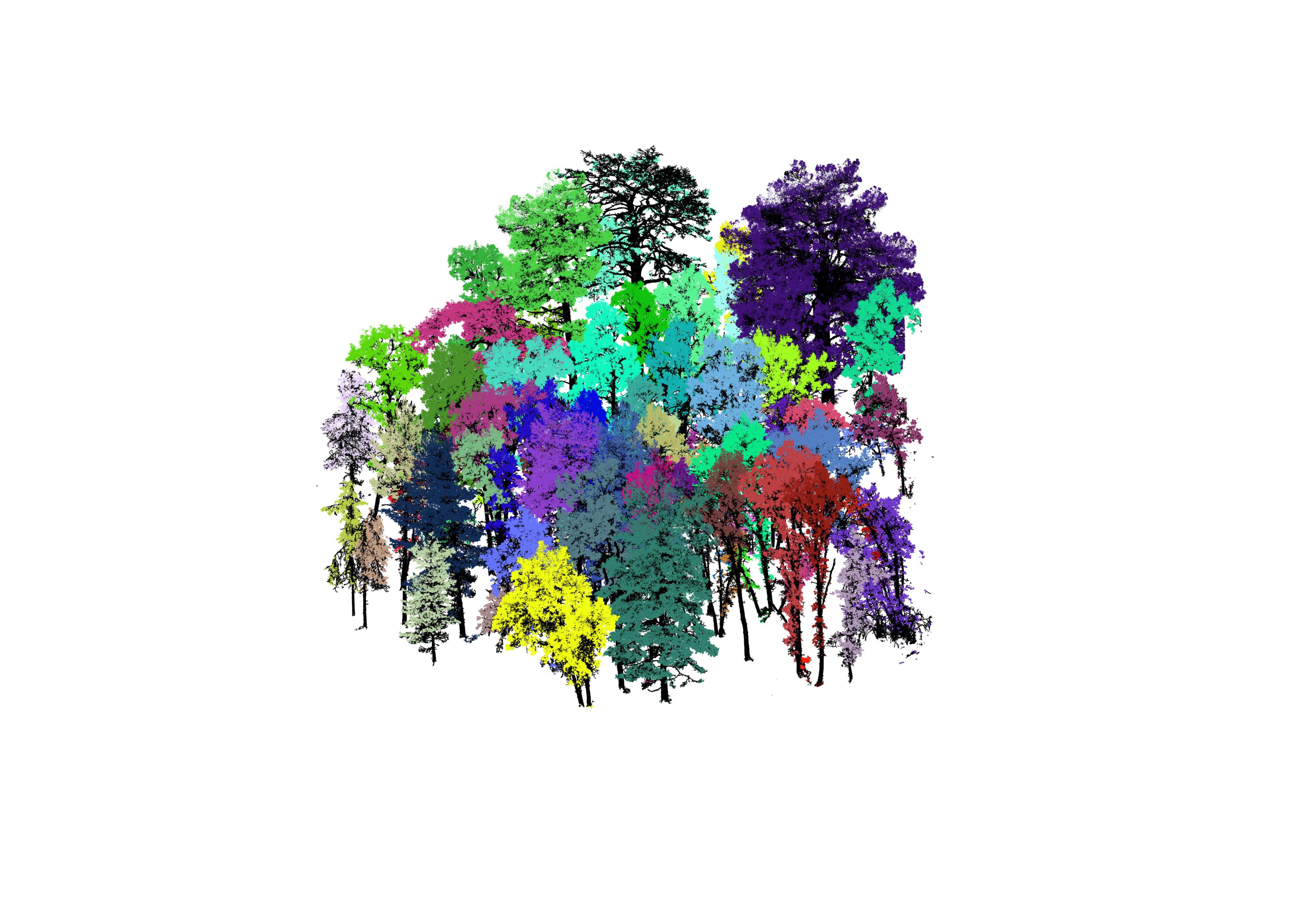

Data visualisation based on drone data collected from a forest in Europe
Owen's 3D algorithm can identify individual trees, which are shown in different colours, revealing how each tree is growing, its structure and biomass.
The team can use this data to determine essential biodiversity variables (EBVs) - such as ecosystem function and structure, genetic diversity and population abundance. EBVs act as indicators for biodiversity success in certain areas.
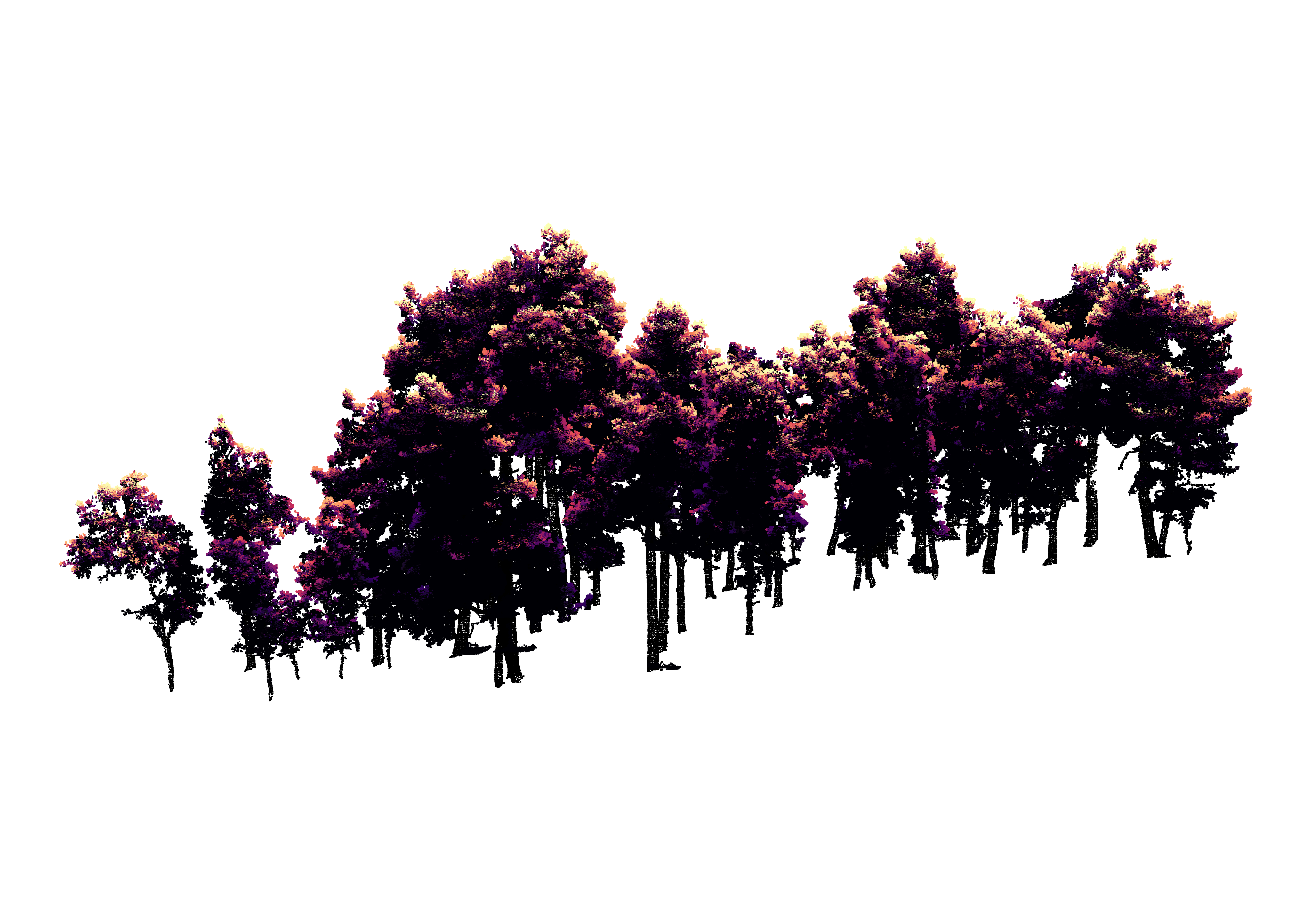
Forest-light tracing algorithm developed by Owen.
Owen is then using this 3D data to understand how light is scattered throughout the forests ecosystem. He has developed a further algorithm which highlights areas of direct sunlight and shade within the forest.
Intercepted light within the forest creates microhabitats in shaded areas. These may be beneficial to particular species in very dry or hot places.
Microhabitats are essential for species biodiversity within the forest. The team hopes that understanding where they are located will help to inform how they can be better protected.
In order to use AI to accurately process the large amount of complex and dense data for modelling individual trees, Owen had to build their own algorithm from scratch.
“There are all these ‘segment anything’ algorithms out there but they massively fail on our datasets because natural ecosystems are far more complicated,” Lines said.
The intricacies of nature require an AI model that is trained on rich high-quality data. By using fewer samples, but of higher resolution data (instead of more samples of lower quality data) they are reducing unnecessary computer-processing power and cutting the environmental impact of training the model.
Owen is also accounting for different types of forests, not just in European regions. He hopes that users across the world can harness the AI model to speed up the processing of data, from tropical to boreal forests.
The pair hope this AI model will accelerate forestry data processing, providing stronger evidence for improved policies and programmes for carbon accounting and biodiversity credits.
My group has a mixture of people, but I make everyone go and collect data at least once - I honestly don’t think they’re going to understand the data otherwise, plus I like going outside,” said Lines.
Satellite imagery provides limited insights compared to ground-based techniques like Terrestrial Laser Scanning (TLS) which offers high-resolution 3D visualisations of forest structures. TLS has been revolutionary for forest monitoring, allowing researchers to understand ecological questions about tree size and carbon stock more accurately previously possible.
Lines and her team are also using drones with laser sensors to cover a much greater area than possible with ground-based monitoring instruments. The detailed 3D scans offer a wealth of information for forest managers and conservationists, but turning the data into useful insights is a time-consuming process.
Relatively cheap commercial drones can address these challenges by providing smaller datasets which are more manageable and can be processed more efficiently.
"These new technologies should give us much better biodiversity and monitoring indicators, which will help us to get better, repeatable metrics - AI is just a tool, but it helps us get there faster,” said Lines.
The pair recently published a paper alongside academics from Queen Mary University of London highlighting how similar UAV-drones can detect ash dieback disease in individual trees. Another study completed by the pair revealed how laser scanning data can provide substantially better measures of tree and forest structure than traditional methods.
Terrestrial Laser Scanning in action
This project is one of several projects under a new Cambridge focus on AI for Climate and Nature, which has received seed funding from ai@cam, the University’s flagship AI mission.
AI for Climate and Nature is an interdisciplinary collaboration between Cambridge Zero, Cambridge Conservation Research Institute,Conservation Evidence, Institute of Computing for Climate Science, Centre for Landscape Regeneration,Cambridge Centre for Carbon Credits (4C), Cambridge Conservation Initiative, Cambridge Centre for Earth Observation and the Dawn supercomputer.


Find out more at:
http://ai.conservation.cam.ac.uk
https://eo.conservation.cam.ac.uk
Published 26 July, 2024
Images: Emily Lines
The text in this work is licensed under a Creative Commons Attribution 4.0 International License